Development of the “Old Port” at Wynyard as a Marina for North West Tasmania.
![]()
This image from Google shows the area known as the Old Port located 1.5 km East of the Wyhyard CBD. Before the Inglis River breakwall was built a century ago this area was the port for Wynyard. It was swept by the currents from the Inglis and was 9 Metres deep. 30,000 pounds was spent on the construction which was a lot of money back then.
Current Situation for Boat Berths and Moorings. North Western Tasmania has a shortage of space for Fishing Boats and Yachts. Port Sorrel:- 10 Moorings at Squeaking Point.(1.3 Metre Draft.) 20 Small Boats on Hard Stand at Muddy Creek. Access 50% at High Tide. Devonport:- 30 Berths at Yacht Club Marina, 35 Mooring in Basin. Ulverstone:- 5 Berths at Wharf, 5 Moorings in River Burnie:- 0 Wynyard:- 15 Berths. Access 50% of Time at High Tide. Stanley:- 22 Berths for Fishing Boats Smithton:- 5 Berths for Fishing Boats. Access 50% of Time at High Tide There is no spare capacity at any of these locations. The devastation caused by the Floods in 2016 showed how precarious the berths in the Mersey and Inglis Rivers are. The tidal flow in these rivers causes electrolysis problems. In the Hobart Estuary and D’entrecasteaux Channel there are over 6000 berths and moorings. State wide there are 4,300 Moorings (Only 70 in the North West). There is 30,000 registered boats in the state. An indication of the economic activity this infrastructure generates is the fact that in the Yellow Pages 116 Marine Services are listed in Southern Tasmania and only 36 in Northern Tasmania. Advantages to development of the Old Port:- The Port would provide the only safe all weather/all tide launching ramp between Ulverstone and Stanley when rescue or sanctuary is needed. The Area usable for berths/mooring inside the Port is around 10 Hectares. Lindesfarne Marina in Hobart is 2.5 Hectares in area and has berths for 100 boats. There plenty of capacity to accommodate Larger Yachts and Fishing Vessels. More boats more economic activity for the region. The port has the capacity to provide a hub to re-establish the scale fishing fleet for Bass Strait that once existed. All the current Commercial Fishermen in the region support the plan. With the channel properly lit sailors can safely return any-time. The local fishing fleet can save time and inconvenience. Added safety for rescue etc
Proposed Development to turn the 'Old Port' into the New Port This paste-up has sections cut and pasted to scale from the Kettering Marina, Wynyard Yacht Cluband Wharf
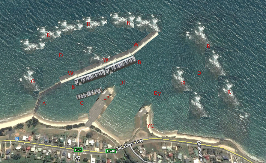
Legend:- R:- The current reefs form an outer circular barrier of ~500 Meter Radius centred on the mouth of Port Creek. By raising this ring on reef by between 0 and 1 meter the power of the waves will be lessened. The outer reefs could be raised by using a LARGE bulldozer with rippers working at low tide. This would form a drainage trough behind it. On the eastern side an inner wall(IR) could be built in a similar manner with the excavated materials used to raise the Yacht Club site(YC) and the Boat Ramp site(LP). W:- The present Sea Wall is currently. 450 Meters Long. This can be extended to .7 Km by raising the current reef by between 1 and 2.5 Meters using material on site. The Pyroclastic Rock between the outer reef and this wall can by quarried using a LARGE bulldozer with rippers working at low tide to build up the an area of dry land behind the sea wall and to rebuild the access road adjacent to the shop(W, A). This section image is pasted from the Wynyard Wharf and is slightly above scale. The Wynyard Wharf is 60 Metres long so this wharf/wall is ten times longer. B:- Berths for large vessel consists of poles and floating decks as described below. This section is pasted in from the outer wall at the Kettering Marina and is to scale to show proportion. The Kettering wharf is 225 Meters long so X2 fit along the 450 meter present wall. C:- Berths for smaller vessels accessed from car park. This section is pasted in from an inner wall at the Kettering Marina and is to scale to show proportion. This wharf is 100 Meters Long. LP:- The central inner reef(LP) of the Port would provide the only safe all weather/all tide launching ramp between Ulverstone and Stanley. The northern edge of this reef is at the low water line. 50 Meters out there is 1 Meter depth at low tide. Raising the reef level by .5 Meters would provide car and trailer parking. The parking area is 60 Meters wide by 150 Meters long. This section is pasted in from the Wynyard Yacht Club ramps and is to scale to show proportion. It is 60M widell A:- Access Road to Wharf to be replaced if required to berths/moorings. D:- Areas to be Dredged. To use the boat ramp all tides Dl need deepening .5 Meter IR:-raised inner reef to stop surge in extreme weather.. G:- Reef to be left in place to hold back sand from the beach to the west. YC:- The reef on the eastern side of Port Creek(YC) could be allocated to the Wynyard Yacht Club as an all tidal launching area seperate from the power boats. The northern edge of this reef is at the low water line. 50 Meters out there is 1 Meter depth at low tide. The area of the Reef could be easily enlarged be excavating adjacent to give more depth at low tide.
Excavations:- Note:-What makes this project feasible is the nature of the rock in this area needed to rebuild the walls. It is a form of volcanic 'piroclastic flow'. This is soft and easy to excavate with todays machinery. When crushed it can make super strength concrete. Current Situation. There is 1-1.5 Meters depth near the eastern end of the sea wall and in the channel at low tide. To start with an excavator could lower the depth near the boat ramp and yacht club to allow access. Listed here are the volumes of sand dredging required for depth at low tide Boat Ramp only: dredging:- 50M X 50M X .6M = 1500 Cubic Meters Boat Harbour Channel:- 100M wide X 450M long X 1M deep = 45,000 Cubic meters Inner Harbour:- 100M wide X 450M long X 2M deep = 90,000 Cubic Meters Total:- 135,000 Cubic Meter Time to remove @ 1000 Cubic Meters per day:- 135 days(case history for these figures below) The sand removed could be pump to build up the beach to the east and to create dry land behind the wharf. Total removal is not needed immediately and can be done in stages. Listed here are the volumes of rock/sand to be relocated for wharfs and walls Fill on boat ramp parking area:- 60M X 150M X .6M = 5400 CM Wharf: To replace the current wall:- 450M X 20M X 1M(avg) = 9000 Cubic Meters To extend to wall to 700M:- 350M X 30M X 1.8M(avg) = 18,900 Cubic Meters. To add an area of dry land behind main wharf:- 450M X 20M X 1M = 9000 Cubic Meters To replace the old access road to the Wharf:- 300M X 6M X 1.5(avg) = 2700 Cubic Meters By building the road on the western side of the current wall the sand has already built up to near the high tide mark so considerable material is saved. It’s recommended that a bridge be used to connect between the eastern side of reef(G) to the wharf to allow a current to flush the harbour.
Case Study of Sand dredging on the Gold Coast
Councils maintaining waterways with dredging is common practice around the Gold Coast, Lakes Entrance and the inland lakes and at the Illawarra in NSW.
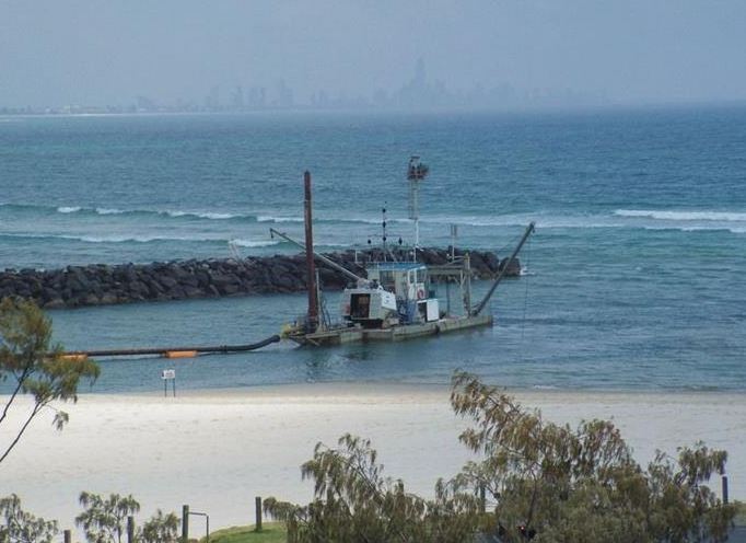 Article on Sand Dredging Tallebudgera Beach
This website below shows the type of operations used by the Gold Coast Council to maintain their waterways
Dredging - Marine Dredging Contractor on the Gold Coast, Queensland, Australia | Neumann Contractors
Video:- Dredge Pump---Sand Dredge Pump Using In European Market
Wharf infrastructure:-
The Port has a 2.5 meter tide range. The Berthing System would consist of a floating walkway parallel with the seawall with poles and a floating walkway to give access to two boats. The spacing of the poles would be variable to accommodate different boat sizes.
Article on Sand Dredging Tallebudgera Beach
This website below shows the type of operations used by the Gold Coast Council to maintain their waterways
Dredging - Marine Dredging Contractor on the Gold Coast, Queensland, Australia | Neumann Contractors
Video:- Dredge Pump---Sand Dredge Pump Using In European Market
Wharf infrastructure:-
The Port has a 2.5 meter tide range. The Berthing System would consist of a floating walkway parallel with the seawall with poles and a floating walkway to give access to two boats. The spacing of the poles would be variable to accommodate different boat sizes.
 When a new boat wants a berth the owner can pay for a pile and floating walkway which could be supplied by local business. They could be floated on the pipes used for the salmon farms nets and are produced locally.
Pivoted walkways from the wharf to the parallel walkway for access.
A loading dock re-established at the eastern end of the wharf for loading/unloading.
Plant Required:-
A barge similar to the one below would be required to develop and maintain the Port. A pile-driver would be fitted to one end and a sand-dredge could be mounted on the deck and with a capacity of 120 tonnes it could be used as a platform for other plant such as excavators etc.
When a new boat wants a berth the owner can pay for a pile and floating walkway which could be supplied by local business. They could be floated on the pipes used for the salmon farms nets and are produced locally.
Pivoted walkways from the wharf to the parallel walkway for access.
A loading dock re-established at the eastern end of the wharf for loading/unloading.
Plant Required:-
A barge similar to the one below would be required to develop and maintain the Port. A pile-driver would be fitted to one end and a sand-dredge could be mounted on the deck and with a capacity of 120 tonnes it could be used as a platform for other plant such as excavators etc.
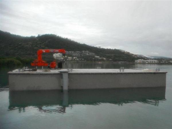 Example Barge:- 50 by 30 foot Flat Top Dumb Barge asking price $75,000.| Boats Online for Sale
There are rocks just outside the outer wall to the North and West which are deadly for boats at low tide these could be removed by loading an excavator on a barge like this.
Recommended Timescale:-
This doesn't need to all be done at once. Dredging the channel and creating the all weather. all tide boat ramp would be first. D9 dozers and large excavators could rebuild the buffer walls/whalf over time at low tides.
It's expected 2 full time employees could run the barge with sand dredge and pile driver during construction. All mooring piles driven at owners expense.
Example Barge:- 50 by 30 foot Flat Top Dumb Barge asking price $75,000.| Boats Online for Sale
There are rocks just outside the outer wall to the North and West which are deadly for boats at low tide these could be removed by loading an excavator on a barge like this.
Recommended Timescale:-
This doesn't need to all be done at once. Dredging the channel and creating the all weather. all tide boat ramp would be first. D9 dozers and large excavators could rebuild the buffer walls/whalf over time at low tides.
It's expected 2 full time employees could run the barge with sand dredge and pile driver during construction. All mooring piles driven at owners expense.